The Sky as the First Calendar and Compass
The recurring sky was among humanity’s earliest references for time and direction. From Sopdet and Maya cycles to Polaris and Pacific wayfinding, people learned to turn celestial patterns into calendar and compass.
Before calendars on walls, watches on wrists, magnetic compasses, and satellite navigation, there was a much older system of orientation: the recurring sky.
The Sun rose and set. The Moon changed phase. Some stars returned at similar times of year. The Sun's rising and setting points shifted along the horizon through the seasons. Some stars circled the celestial pole, while others rose and set at characteristic places.
People did not need to understand gravity, Earth's orbit, or spherical astronomy to notice one crucial property of these phenomena: they repeat. Repeatability is what makes a natural phenomenon useful as a reference.
The title “the sky as the first calendar and compass” is therefore not meant as a claim that we can historically prove one single moment when somebody invented the first calendar or the first system of orientation. We do not possess such a universal history. What we can say with much greater confidence is that observing celestial cycles was among the earliest repeatable ways by which people measured time, recognized seasons, and maintained direction.
The sky was not only an image above humanity. It was a recurring reference.
Before the clock came the cycle
When we think of time today, we often imagine it as a number: 08:30, 17:45, 28 August, the year 2026. But a number does not create time by itself. It needs a recurring phenomenon to which we attach it.
A day is connected with Earth's rotation relative to the Sun. A year with Earth's orbit around the Sun. The phases of the Moon form a highly visible cycle that can be followed without instruments. The annual change of the night sky is also a consequence of looking in different directions into space as Earth travels around the Sun.
For a community without a mechanical clock, a more useful question than “what time is it?” might therefore have been: how high is the Sun, which lunar phase is visible, which star appears before dawn, which part of the sky is visible after dusk, and where along the horizon does the Sun rise or set?
The International Astronomical Union emphasizes exactly this in cultural astronomy: many cultures used the motions of the Sun, Moon, and stars in systems of timekeeping and to anticipate seasonal changes, planting, harvest, and periods of ritual observance.
That does not mean that the sky was the only calendar. People also observed rain, plants, animals, temperature, rivers, and other environmental signs. The important point is the connection. A celestial phenomenon often served as a repeatable marker that could be linked with events on Earth.
A calendar begins with return
A calendar is not first a table. First, a cycle has to be recognized.
If a phenomenon returns in a characteristic sequence, it can become a temporal reference. Lunar phases recur. The Sun's height changes through the year. Its rising and setting positions move and then reverse direction. Stars that have been hidden for a time in the Sun's glare can reappear for the first time in a particular part of the year shortly before dawn.
Astronomers call such a star's first annual appearance before sunrise its heliacal rising. For an observer without a modern calendar, this can be striking because a familiar bright object reappears in the morning sky after a period of invisibility.
That is why particular stars could become associated with annual transitions in different societies.
But a methodological caution is essential. If a celestial event and a seasonal event occur at roughly the same time, that does not mean the star caused the flood, rain, or harvest. The sky functions as a marker of time, not as the cause of the seasonal event.
That distinction matters.
Sopdet, Sirius, and the Egyptian year
Ancient Egypt offers a well-documented example of linking astronomical cycles with calendar time.
The Metropolitan Museum of Art explains that by at least the middle of the Old Kingdom — and possibly several centuries earlier — Egyptians had developed a civil calendar of twelve thirty-day months plus five additional days. The year was divided into three seasons associated with inundation, emergence or growth, and harvest.
A lunar reckoning also existed alongside it; the beginning of the lunar month was associated with the disappearance of the waning Moon. A particularly interesting star is Sopdet, also known by the Greek name Sothis and the Latin name Sirius.
The Met notes that Egyptian New Year's Day was probably originally associated with the heliacal rising of Sopdet. Its reappearance before dawn occurred at about the same time as the first signs of the annual Nile flood.
But this connection did not remain permanently fixed to the same civil-calendar date. The Egyptian civil calendar had 365 days, while the tropical year is slightly longer. Without a leap-day correction, the civil date therefore slowly drifted relative to the seasons and the stellar event.
That detail is especially instructive. The sky did not merely make a calendar possible. It also made it possible to notice that a calendar and a natural cycle are not necessarily exactly the same thing. A map of time can begin to drift away from the phenomenon it is meant to describe.
The horizon as a measuring line
Observing the sky does not necessarily require numerical coordinates. A well-known horizon can be enough.
The Sun does not rise at exactly the same point throughout the year. At most latitudes, its rising point shifts along the horizon between extreme positions around the solstices. Its setting point changes in a similar way.
If an observer watches each day where the Sun rises relative to a hill, tree, rock, or another stable feature on the horizon, the landscape becomes part of a natural annual indicator. The same principle can apply to stars. If we know where a particular bright star rises or sets, its appearance in a certain part of the horizon can help mark a direction or a part of the year.
This is why early astronomy did not necessarily mean looking high into the sky with abstract coordinates. Often it involved a relationship between the sky and the local landscape. The horizon became a measuring line.
At this point calendar and compass begin to approach one another: the same rising or setting of a celestial body can tell us something about time and something about direction.
The sky as calendar is not only a thing of the past
If we presented all of this only as a story about “ancient civilizations,” we would make a mistake similar to the one discussed in the article “The Same Sky, Different Worlds”: we would turn living traditions into museum objects.
The Smithsonian project Living Maya Time shows that among Maya communities the relationship between the sky, agricultural cycles, and calendar knowledge has deep historical roots, but is not merely a thing of the past.
The Maya developed several calendar systems and carefully observed cycles of the Sun and other celestial bodies. Observations of the Sun along the horizon, zenith passages, and other recurring phenomena were connected with understandings of the year, agricultural cycles, and ritual time.
The project also documents that observational astronomical knowledge is still used in some Maya communities today when planning agricultural and ceremonial cycles. This is an important correction to the idea that a calendar is invented once and then exists independently of the world.
In many systems, a calendar remained for a long time a living relationship between recurring phenomena, local environment, and human practice. When people observed the sky, they were not necessarily measuring abstract time alone.
They were asking: what is approaching now?
When the sky becomes a compass
Time is not the only information available from a recurring sky. If we understand the apparent motion of the Sun and stars, we can also obtain direction from them.
The Sun gives a rough indication of east when it rises and west when it sets, but it does not rise every day exactly at geographic east. That happens only at particular times of year. More precise orientation therefore requires knowledge of its seasonal motion.
Stars offer other possibilities.
Stars near a celestial pole appear to circle around almost the same point. Other bright stars rise and set on characteristic parts of the horizon. If a navigator knows their paths, they can maintain direction without a magnetic needle.
IAU educational material on navigation in the ancient Mediterranean explains that experienced navigators knew bright stars and constellations and used their rising, setting, and apparent motion around the celestial pole for orientation.
Stars were therefore not only images by which stories could be remembered. They could serve as directional references.
Polaris is useful — but it is not eternal north
Today, in the Northern Hemisphere, the easiest example of stellar orientation is Polaris, the North Star.
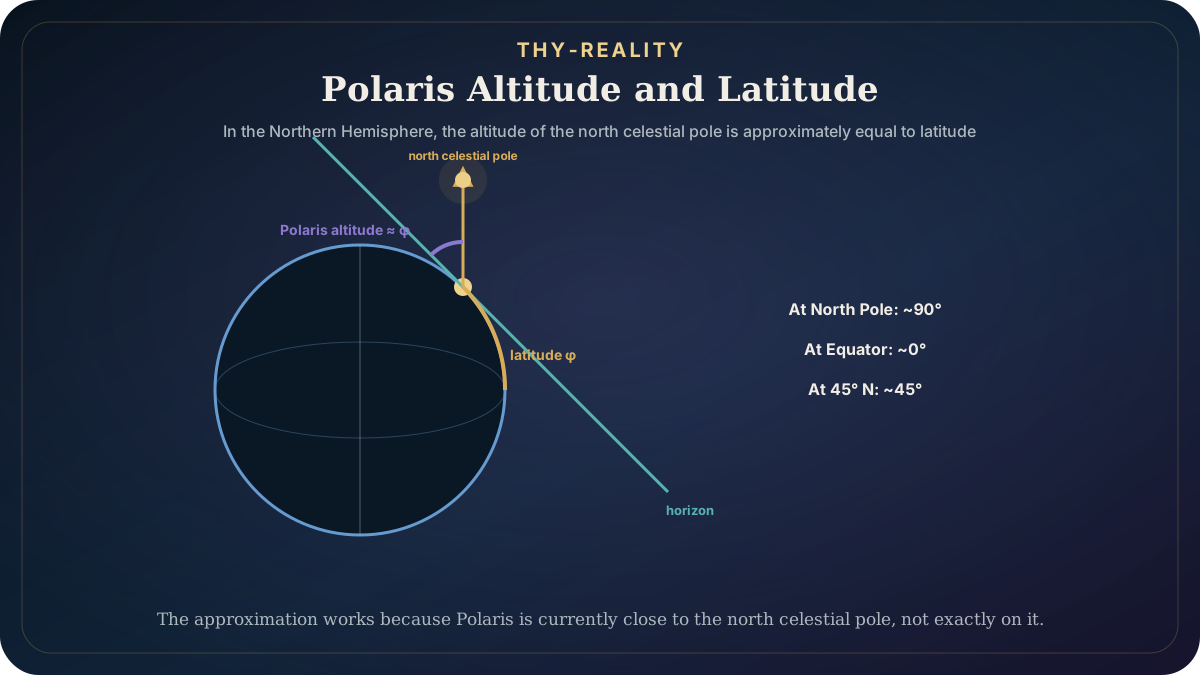
Because it lies close to the north celestial pole, other stars appear to rotate around it. The altitude of the north celestial pole above the horizon is related to the observer's latitude; NASA therefore explains that measuring the altitude of Polaris above the horizon in the Northern Hemisphere gives a fairly close approximation of latitude.
But even this apparently ideal celestial compass has limits. First, Polaris cannot serve as a northern reference from the Southern Hemisphere, where it is not visible. Second, it has not always been as close to the north celestial pole as it is today.
Earth's rotational axis slowly changes direction through precession. IAU educational material notes that in the Bronze Age Polaris was far from the celestial pole, while Thuban in Draco was a more suitable reference.
This is a useful example of the difference between a rule and the conditions under which it works. “Find Polaris” is not a universal and eternal method of celestial navigation. It is a method that works in a particular part of the world and during a particular portion of the precessional cycle.

An ocean star compass is not just a list of stars
One of the strongest examples of the sky as a navigational system is found in Pacific ocean wayfinding.
Polynesian and Micronesian navigators developed bodies of knowledge that made it possible to cross great distances of open ocean without modern navigational instruments. But this knowledge should not be reduced to the romantic formula “they followed the stars.”
Stars were only one part of the system.
In its account of the modern voyaging canoe Hōkūleʻa, the Smithsonian describes orientation through the positions of stars, the Sun, and the Moon, together with waves, wind, birds, and other environmental signs.
In contemporary Hawaiian wayfinding, an important role is played by the Hawaiian Star Compass, developed by navigator Nainoa Thompson while learning and rebuilding navigational knowledge in a process deeply connected with the Micronesian master navigator Mau Piailug.
The Polynesian Voyaging Society describes it as a mental construct, not a physical compass. The horizon is divided into 32 “houses” associated with the rising and setting directions of the Sun, stars, Moon, and planets.
We have to be precise here.
The modern 32-house Hawaiian star compass should not simply be described as an unchanged ancient instrument. It is a contemporary framework for teaching and orientation within a revitalized tradition of non-instrument wayfinding, drawing on deeper Pacific navigational knowledge.
Its value lies precisely in showing something fundamental: a compass does not have to be an object. It can be a learned relationship between the observer, the horizon, and recurring phenomena.
The sky is a powerful reference, but not a perfect one
If the sky provided perfect navigation and a perfect calendar without any other information, humanity would never have needed precise clocks, chronometers, compasses, ephemerides, sextants, radio, or GPS. Celestial orientation has limits.
Clouds can hide the stars. The horizon can be obscured. Some objects are seasonally invisible. Methods change with latitude. Errors accumulate over a long journey. Stars can help determine direction and, in particular methods, latitude, while accurately determining longitude at sea was historically a much harder problem because it required very precise timekeeping.
That is why even highly developed traditional navigational systems did not rely on a single source of information. The observer had to combine several signals. This is the same epistemological pattern that appears throughout THY-REALITY: an individual datum can be useful, but a more reliable picture emerges from the relationship among multiple pieces of information.
The sky was extraordinarily useful because it offered something the local landscape cannot provide on the open ocean: a large, recurring reference framework above the observer. But even that framework required knowledge, memory, error correction, and an understanding of circumstances.
The sky did not give humanity a finished calendar and compass. It gave recurring phenomena from which people could learn to measure time and maintain direction.
The previous two articles showed how patterns arise from the apparent positions of stars and how different cultures organize those patterns into different maps. Here we add a third layer: those maps did not serve only to explain the world — they could also be tools for living in it.
In the final article of this introductory sky sequence, we will look at something different. How did the many historical traditions and differently divided skies eventually lead to today's international system of 88 official constellations?
The article “How We Got Today’s 88 Constellations” continues that story.
Sources and further reading
- International Astronomical Union. Commission C5 Cultural Astronomy — Scientific Objectives. Source
- The Metropolitan Museum of Art. Telling Time in Ancient Egypt. Source
- Smithsonian National Museum of the American Indian. Living Maya Time — Calendar. Source
- Smithsonian National Museum of the American Indian. Living Maya Time — Maya Sun. Source
- Smithsonian National Museum of the American Indian. Connecting Earth and Sky. Source
- International Astronomical Union / astroEDU. Navigation in the ancient Mediterranean and beyond. Source
- NASA Science. Basics of Space Flight — Chapter 2: Reference Systems. Source
- Smithsonian Center for Folklife and Cultural Heritage. Guiding Us Home: Traditional Hawaiian Wayfinding Aboard Hōkūleʻa. Source
- Smithsonian Ocean. Circumnavigating our Changing Oceans. Source
- Polynesian Voyaging Society / Hōkūleʻa. The Star Compass. Source