Stone Towers and the Putorana Plateau — Volcanic Geology, Natural Geometry, and the Question of Builders
How can we distinguish natural stone towers on the Putorana Plateau from possible human modifications? Volcanic geology, fractures, erosion, and archaeological tests.
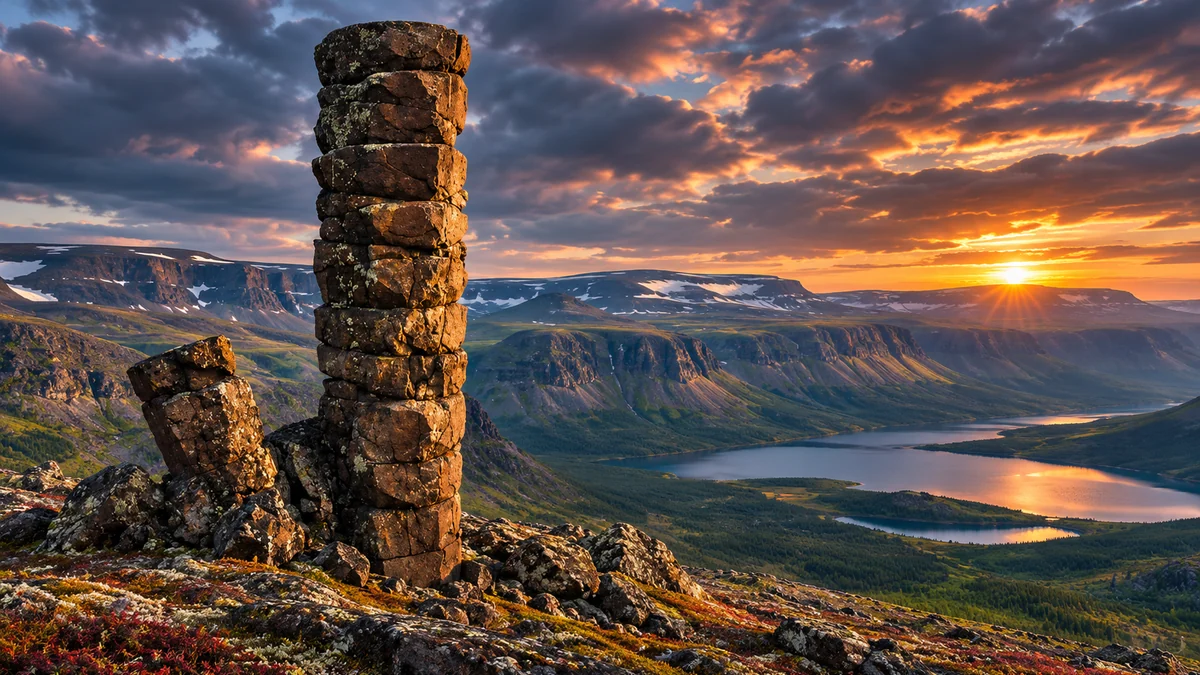
An artistic interpretation of a segmented stone tower in a landscape inspired by Putorana. This is neither a documentary photograph nor a verified reconstruction of the tower shown in the online post.
Stone Towers: When Does Nature Resemble Architecture?
Sometimes a rock formation almost involuntarily makes us wonder who built it. A wall rises in straight sections, blocks appear to be arranged in courses of masonry, and an isolated rock on a narrow ridge resembles a watchtower. Such shapes are not merely products of the imagination: around the world, we find stone columns, natural steps, and seemingly regular “stacks” shaped by fractures, cooling magma, water, wind, and ice. On the other hand, some truly remarkable stone structures are human creations. Appearance alone is therefore not enough to decide between the two.
In the middle of northern Siberia lies the Putorana Plateau, an almost textbook example of a landscape where natural geometry meets the appearance of architecture. Extensive layers of volcanic rock rise above valleys in stepped cliffs, while sections of rock break into elongated columns and angular pieces. Photographs of such landscapes may evoke ruined cities, fortifications, or temple foundations, although many of the forms have well-understood geological origins. [1] [2] [3]
This raises an intriguing research question: how can we distinguish a naturally formed rock feature from a structure built or reshaped by people? Neither the claim that “nature cannot do this” nor the opposite assertion that “nature can do anything” is an adequate answer. We need to investigate the rock type, the orientation of fractures, the surrounding relief, weathering patterns, and any traces of human work. In the case of Putorana, we have sound scientific documentation of the landscape as a whole, but not every individual stone tower has been studied equally well.
This article is therefore not a verdict on a single photograph circulated online. It investigates the geological processes that create unusually regular forms, together with the archaeological criteria by which bolder hypotheses about builders could be tested. The question remains open wherever reliable field data are lacking; an unknown, however, is not in itself evidence for any particular answer.
Putorana: A Landscape of Volcanic Steps
The Putorana Plateau lies in the northern part of central Siberia, east of Norilsk. It is an extensive and relatively remote upland crossed by deep valleys, river gorges, and long, narrow lakes. Its flattened summits and steep slopes create a surprisingly regular silhouette, as though the mountains were composed of a succession of terraces. In 2010, UNESCO inscribed the central part of the area, corresponding to the Putorana Nature Reserve, on the World Heritage List. The designation is based primarily on its natural features and the preservation of Arctic and subarctic ecosystems. [1]
The geological foundation of this landscape is the Siberian Traps—an immense volcanic province that developed around the Permian–Triassic boundary approximately 252 million years ago. Lava and other igneous rocks formed through widespread eruptions and magma intrusions; over millions of years they were subsequently affected by uplift, fracturing, weathering, and erosion. Recent geological reviews also associate eruptions and underground magmatic intrusions with major environmental changes at the end of the Permian, although the details of the causal mechanisms remain under investigation. [4]
The term traps derives from the characteristic stair-step appearance of the terrain. Successive lava flows and other rock layers do not have uniform thickness, composition, or resistance everywhere. Where a less resistant layer retreats more quickly than a stronger one, a ledge remains; where fractures cut across the strata, troughs, valleys, or steep walls may develop. The region is not one solid mass of basalt, but a complex succession of volcanic and other rocks subsequently reshaped in different ways. [2] [12]
UNESCO and UNEP-WCMC descriptions specifically mention deep canyons, large lakes, and numerous waterfalls associated with this stepped structure. In a satellite image, the European Space Agency drew attention to the pronounced layering and dissected relief. From satellite altitude, broader geometric patterns become visible, allowing geologists to compare the orientations of valleys, faults, and slopes. Such an image cannot, however, tell us whether someone moved, worked, or photographed an individual rock. [1] [2] [3]
It is important to distinguish two different timescales: the rock may be approximately 252 million years old, whereas the present shape of a tower or fractured cliff may have developed much later. If someone worked ancient rock in more recent times, the date of its magmatic crystallization would not reveal when that work took place. This distinction is fundamental to any fair assessment of alleged prehistoric construction.
How Lava Creates Stone Columns
As a thick lava flow cools, the rock contracts. Stresses build up and are released through fractures. Under certain conditions, the fractures propagate in ways that divide the rock into long, often polygonal columns. Hexagonal cross-sections are particularly recognizable, but they are not the only possible form: four-, five-, seven-sided, and other columns also occur, and regular sections may alternate with highly disordered ones. [5]
When describing cooling basalt flows, the U.S. Geological Survey (USGS) distinguishes more regular columns formed during slower cooling from zones of densely spaced, irregular fractures. Within one volcanic wall, therefore, two apparently contradictory images can occur: an almost orderly colonnade below and something resembling shattered masonry above. These features are not the result of stones being stacked later, but of internal fracturing within the original rock mass. [5]

Similar examples occur in Northern Ireland, Iceland, along the coast of the Kuril Islands, and in many other volcanic regions. Their geometric similarities do not in themselves imply contact between cultures; many are the result of comparable physical processes. For Putorana, it is important that columnar jointing is not merely inferred from examples elsewhere. In 2023, the Russian Geographical Society published field photographs of such formations and identified different parts of the plateau where they can be observed. [7]
Nevertheless, not every straight line in basalt is a columnar joint. Some lines separate individual lava flows, others are later tectonic fractures, and still others appear when the rock breaks along pre-existing weaknesses. Columns themselves may also be fractured across their length. The USGS explicitly describes near-vertical columns in the Columbia River basalt region cut by horizontal or nearly horizontal joints. At a distance, such a combination can look like courses of laid stone blocks. [6]
A genuine geological investigation would therefore do more than announce that “this is basalt.” It would measure the orientation and spacing of fractures, their continuity through the rock, the rock's composition, and its connection to the bedrock. If supposed “masonry joints” continue into the surrounding rock, that strongly supports a natural explanation. If portions proved to come from different rock sources and to have been placed on a prepared base, the possibility of human intervention would deserve serious examination.
Water, Ice, and Frost: The Long Shaping of Today's Relief
A lava eruption is only the beginning of the story. Exposed rock is subsequently subjected, over millions of years, to water, gravity, temperature fluctuations, and ice. These later processes are particularly important on Putorana. A scientific geomorphological study by Buček, Kolejka, and Kostka published in 1996 describes strong periglacial activity and ancient glacial valleys dissected along tectonic faults. The researchers also examine differences in the resistance of basalt, diabase, dolerite, and volcanic material. [8]
Water entering a crack needs no chisel to affect stone. If it penetrates between the walls and freezes under suitable conditions, expanding ice can enlarge the fracture. Repeated cycles can gradually detach a piece of rock. The British Geological Survey describes frost weathering as a form of physical rock breakdown; this does not mean, however, that every fracture in a cold region was caused exclusively by freezing water. [9]

Gravity then acts on steep slopes. Blocks break away, slide, accumulate as scree, or are carried off by water. If the surrounding rock deteriorates more rapidly than a resistant central section, an isolated tower-like outcrop may form. Where fractures intersect at roughly right angles, such an outcrop can acquire an outline resembling stacked rectangular stone blocks. Shadows falling into the joints may reinforce the impression.
Geomorphologists also recognize comparable isolated rock outcrops, or tors, in granite mountain ranges. Fracturing and selective weathering are crucial to their development. A granite tor, however, is not automatically a model for a basalt outcrop: different rocks have different internal structures and histories. The comparison helps explain general processes; it is not field evidence that an unidentified tower formed in precisely this way. [13]
Looking at Putorana, we see a combination of ancient volcanic rock structure and much more recent reshaping. Stepped slopes, columnar jointing, widening fractures, and the detachment of blocks may all belong to the same geological story. Without observations at a particular site, however, their timing and causal relationships cannot be fully reconstructed. Indeed, this layered history is one of the reasons the landscape is so unusual.
What Has Actually Been Documented on Putorana?
When investigating stone towers, it is essential to distinguish verified regional examples from objects whose locations have not yet been established. Documented natural features of Putorana include extensive stepped basalt cliffs, columnar joints, rock scree, canyons, and waterfalls. Their existence is supported by independent geographical descriptions, satellite images, and field documentation. [1] [2] [3] [7]
In an August 2023 publication, the Russian Geographical Society described striking basalt columns in the upper Ayan River basin and mentioned other areas of Putorana. Its wider coverage of the landscape also shows columns near large waterfalls and river gorges. Such photographs are valuable because they show a specific, geographically situated phenomenon. At the same time, they demonstrate that natural rock can resemble almost regular colonnades. [7]
Lake Lama and its surrounding slopes offer a very different scale of observation. Here, long rock layers alternate with scree, patches of vegetation, and steep rock faces. A broader panorama helps us understand the terrain: an isolated tower is not independent of the mountain but is often a remnant of a structure that continues into its surroundings. Comparing the bedrock, ridge, and adjoining cliffs may be much more informative than studying a close-up of the “tower” alone.
Two already approved images are therefore suitable for documentary illustration in this article: one shows basalt columns beside a waterfall, and the other shows the wider landscape around Lake Lama. Both illustrate verified phenomena on the plateau; neither identifies the particular allegedly constructed tower. Their authorship and licensing must remain attributed as recorded in the existing image documentation.
The significance of these known examples is not that they rule out artificial structures in northern Siberia in advance. It is that, for at least some comparable forms, we have direct documentation of a natural process. Any new claim of construction therefore needs evidence that goes beyond a visual resemblance to known natural formations.
From Natural Fractures to the Appearance of Stacked Blocks
When does a rock wall begin to look like masonry? Most often, this happens where several systems of fractures intersect. Nearly horizontal boundaries create the impression of strata or courses of stone, while nearly vertical joints divide them into apparent rectangular blocks. In a photograph, we see their edges, but not necessarily their interiors or the true contact between what appear to be separate pieces.
In practice, at least three situations need to be distinguished. First, a single rock mass may be divided by fractures into several sections without any of them having been moved. Second, naturally detached blocks may remain leaning against one another, become wedged together, or assume particular positions through slope processes. Third, people may actually transport and stack stones. All three situations may look very similar in a photograph, but their physical evidence in the field differs.
The decisive factor is continuity. If textures, veins, layering, or mineral characteristics continue from one side of an apparent joint to the other, this supports the conclusion that the rock fractured in place. If blocks show differing geological origins and rest on a surface that has been specially levelled, a different explanation becomes possible. Researchers would also need to determine whether the joints bear the weight of higher blocks and whether the surfaces show signs of deliberate shaping.
Perspective can make basalt colonnades even more misleading. Inclined columns may look horizontal in a two-dimensional image; rocks separated in space may appear to touch because of the camera angle; and strong shadows may turn a narrow fracture into a dark band resembling a deep construction joint. Photographs taken from several directions, an object for scale, and a three-dimensional survey are therefore far more useful than a single dramatic frame.
This analysis does not mean that every regular-looking formation is “nothing but” nature. It means that we must distinguish the shape we see from the process that produced it. Rocks and buildings may display similar geometries; the difference is revealed by physical traces rather than by our first impression.
What Would Human Modification of a Rock Formation Mean?
The hypothesis of human builders is testable if it specifies which physical evidence we should expect to find. Perfectly rectangular blocks or remains of metal tools are not essential: in different periods, people built with irregular stones and without metal implements. Nevertheless, some positive traces of human activity are necessary to distinguish construction from geological disintegration.
Researchers would first examine the base. Does the tower rise directly from the same rock layer as the slope, or does it stand on a specially prepared, perhaps levelled foundation? Can individual blocks be traced to original positions elsewhere, suggesting transport? Are there foundations, supporting structures, or unusually ordered embankments beneath the supposed walls? One regular fracture cannot substitute for such evidence.
Next would come an examination of the surfaces. Marks of striking, cutting, splitting along predetermined lines, or working the edges can be important, but they need to be distinguished from natural fracture surfaces. In cold, dry environments, some features survive for long periods, while others rapidly disappear through frost damage and erosion. Close examination under magnification and comparison with the surrounding rock may therefore be needed, rather than a distant view alone.
Only with archaeological context could we begin to consider dating the intervention. Researchers would look nearby for artefacts, hearth traces, working debris, a path, or another site. If material were found in a reliable stratigraphic association with the foundations, an appropriate method might allow it to be dated. Dating the stone itself is not the same as dating construction: basalt millions of years old could have been used by people in a much younger monument.
There is also an intermediate possibility: a naturally formed tower later modified in part by people—for example, by levelling a platform, using fractures as shelter, or adding a course of stones. Such a find would be no less interesting than an entirely built monument, but it would require equally careful documentation. In the material examined for the alleged Putorana tower, we currently have no such evidence. That does not close the question; it identifies the present evidentiary stage of the hypothesis.
Could Poorly Studied Monuments Remain Hidden in Northern Siberia?
Putorana's great remoteness and the difficulty of fieldwork mean that the available documentation is not necessarily complete. This is a reasonable basis for open research questions. It does not, however, justify assuming that the landscape was uninhabited. Northern Siberia has a long and varied human history associated with hunting, fishing, migration, the use of natural resources, and ways of life adapted to a demanding environment. Various Indigenous peoples have lived, and still live, in the wider region. We should not portray it as empty territory merely awaiting the discovery of a “lost civilization.” [1] [12]
At the same time, a trace of former human presence is not the same as evidence of monumental construction. A pathway, dwelling, hunting camp, and ceremonial location are different types of sites. If previously unknown stone structures were discovered on Putorana, they would pose a valuable archaeological question even if they had been made by a community already known to history rather than by mysterious builders. Demonstrating a widespread architectural tradition, however, would require multiple sites, comparable techniques, and a chronological connection between them.
Research should also be attentive to local testimony. Place names, narratives, and patterns of land use can help guide field documentation. Nevertheless, oral tradition as a historical source needs to be distinguished from material evidence for when and how a particular rock formation originated. Both kinds of material may matter, but they do not necessarily answer the same questions.
The idea of overlooked monuments is therefore a possible research programme, not an established conclusion. We can identify locations for testing, seek reproducible evidence of modification, and publish results that can be independently checked. Such an approach does not diminish the attraction of mysterious stone formations; it offers them a way to become genuine, documented discoveries.
A Photograph Without a Reliable Location: What Can It Tell Us?
Discussion of Putorana gained additional attention through a photograph of an isolated, apparently assembled rock formation that some online posts attributed to the plateau. The image is interesting as a research lead, but the material accompanying the original article did not allow the photographer, original date, precise location, or geological composition of the object to be reliably established. [14] [15]
This matters, but it does not require a lengthy polemic. Without a location, we cannot compare the formation directly with a geological map, check its relationship to the slope, or find additional photographs. Without a scale, we also cannot assess its height or the size of the apparent blocks fairly. Establishing the image's provenance therefore becomes a technical task: find the earliest accessible publication, the photographer's original-resolution image, any metadata, nearby terrain features, and photographs taken from other angles.
One further distinction is crucial: an unverified location is not proof that a photograph is fabricated, just as it is not proof that the object is actually on Putorana. Either claim would require additional verification. In principle, the image could show a natural formation elsewhere, a natural formation on Putorana, a partly modified rock, or a constructed object. Without further information, we cannot reliably classify these possibilities for that particular image.
This does not reduce the value of geological research on the plateau. Putorana has documented stone colonnades and stepped cliffs independently of the photograph. The article can therefore rest on a verified foundation while being explicit about where uncertainty begins regarding the particular object that sparked interest.
Comparing Explanations: What Should We Actually Look For?
The same outward appearance can result from several processes. The point is not to assign every explanation the same probability, but to identify observable, testable traces that each would predict.
| Explanation | What would support it? | What is currently missing for the alleged tower? |
|---|---|---|
| Columnar jointing in basalt | Polygonal columns, characteristic fracture systems, continuity with adjacent volcanic strata | Evidence of rock type, fracture orientation, and connection to the bedrock |
| Stepped layering and erosion | Alternating resistant strata, ledges, detached blocks, joints resembling those in surrounding cliffs | A wider view of the terrain and a geological cross-section |
| A natural isolated outcrop | A more resistant central rock mass, surrounding scree, signs of selective weathering | Detailed description of the relief and rock structure |
| A natural formation subsequently modified by people | Tool marks or added stones on an otherwise natural rock formation | Positive material evidence of intervention and a date for it |
| An entirely built structure | Transported stones, prepared foundations, construction joints, archaeological context | A documented site, measurements, stratigraphy, and associated artefacts |
| Incorrect geographical attribution of the photograph | Reliable identification of another location or the original image | Verified image provenance and coordinates |
These explanations are not all mutually exclusive. A natural rock may later have been modified in part; a reliably located feature may reflect several geological processes. If the photograph turns out to have been taken outside Putorana, the geological analysis of that particular object will need to refer to its actual location. That would not invalidate the general findings about the Putorana Traps.
The greatest advantage of this comparison is its openness to revision. A new close-up photograph might reveal the natural continuation of fractures or an unexpectedly smooth worked surface. A geological sample could confirm or challenge the assumption that the rock is basalt. A field excavation could show that the rock is part of the bedrock—or reveal a prepared construction layer. Each such result would change the assessment on the basis of evidence rather than prior conviction.
What Remains Open—and Why Putorana Is Fascinating Even Without Mysterious Builders
Putorana is extraordinary in its own right. Ancient volcanic eruptions created a vast rock structure, while fractures, uplift, ice, flowing water, and prolonged weathering shaped its present appearance. These processes produce straight cliffs, natural stone colonnades, isolated outcrops, and rows of sharp, almost architectural edges. Scientific studies, geographical documentation, and comparative photographs describe these processes. [1] [2] [3] [4] [5] [6] [7] [8] [9]
We must still distinguish honestly between verified features of the plateau and the characteristics of one particular tower that has not been reliably identified in the available material. We have no confirmed location, detailed measurements, geological description, or archaeological context for that object. We therefore cannot claim that it is conclusively natural; nor can we claim that it was made by unknown builders. For now, the broader conclusion that natural processes on Putorana can create highly regular stone formations is better supported by evidence. That conclusion, however, does not replace an examination of the specific object.
The most interesting question is consequently broader than a verdict on one photograph: how can we recognize human activity where nature has already created forms resembling architecture? The answer lies in combining geology, archaeology, precise documentation, and knowledge of local history. If future research uncovers traces of construction or stoneworking, those findings must be acknowledged and explained. If it reveals that the fractures continue naturally through the bedrock, that too will be an important discovery about the formation of the landscape.
Mystery is therefore not a reason to skip verification. It is a reason to do it better. Putorana reminds us both that nature is capable of forms that look human-made and that the history of human intervention can only be established through convincing material evidence. Both deserve investigation—without dismissal in advance and without presenting the unproven as fact.
Sources and further reading
- UNESCO World Heritage Centre. Putorana Plateau. source Source
- UNEP-WCMC. Putorana Plateau — World Heritage Datasheet. source Source
- European Space Agency. Putorana Plateau, Siberia (2016). source Source
- Burgess et al. The Anatomy and Lethality of the Siberian Traps Large Igneous Province. Annual Review of Earth and Planetary Sciences, 2025. source Source
- U.S. Geological Survey. Columnar jointing provides clues to cooling history of lava flows (2011). source Source
- U.S. Geological Survey. Columbia River Basalt — Flow Interiors. source Source
- Russian Geographical Society. «Мостовая гигантов», миниатюрные «замки» и «трубы органа»: удивительные артефакты, созданные природой (2023). source Source
- Buček, A., Kolejka, J., Kostka, R. Vybrané krajinotvorné procesy ve vulkanickém pohoří Putorana (Tajmyr) / Selected Landscape-Forming Processes in the Volcanic Putorana Plateau. Geografie, 101(3), 232–246 (1996). source Source
- British Geological Survey. Weathering. source Source
- U.S. National Park Service. Devils Tower — How the Tower Formed (a comparative example of a natural isolated rock formation in a different geological landscape). source Source
- Russian Geographical Society. Putorana Plateau: Smoking Mountains, Devoid of Peaks (regional description and photographs). source Source
- The Putorana Plateau Nature Complex — materials submitted for UNESCO nomination, 2008 (description of relief, natural history, and human use of the area). source Source
- Goodfellow et al. Controls of tor formation, Cairngorm Mountains, Scotland (comparative geomorphology of granite tors). source Source
- Turister.ru. Путорана – край загадочный и неизведанный… (travel account; not a geological or archaeological expert assessment). source Source
- Telemetr, archive of posts from the channel ЗАБЫТАЯ ИСТОРИЯ (a secondary trace of how the claim spread; the original photographer has not been established). source Source